This article covers the fundamentals of the Google Maps Static Map API, including constructing API requests, customizing map parameters, and integrating static maps into web pages and applications. We’ll also explore advanced topics like adding markers, paths, and custom map styling. This article teaches you the skills and knowledge needed to leverage the power of the Google Maps Static Map API to enhance your projects with beautiful and informative maps.
Introduction
The Google Maps Static Map API is a service provided by Google that allows developers to generate static map images that can be embedded in their websites, apps, or any digital platform. Unlike interactive maps, static maps are fixed images, making them perfect for scenarios where you want to display a map without user interaction.
Introduction to Google Maps Static Map API
Let’s look at some of the key features that make this API a valuable asset for developers:
-
Customization: With the Google Maps Static Map API, you can customize your maps to fit your application’s unique needs. You can set the map’s center, zoom level, size, and style, and even add markers and paths to highlight specific locations and routes.
-
Easy Integration: Integration is straightforward. All you need to do is construct a URL with various parameters to specify what you want to display on your map, and the API responds with a static map image that you can easily embed in your project.
-
No JavaScript Required: Unlike other mapping solutions, the Static Maps API doesn’t require JavaScript, making it suitable for developers who want to add map functionality without extensive coding or scripting.
Use Cases for Static Maps
Static maps are incredibly versatile and are used for a wide range of use cases:
-
Location-Based Services: You can use static maps to display locations of businesses and points of interest or even show directions.
-
Contact Pages: Many websites include static maps on their contact pages to help visitors visualize a business’s physical location.
-
Travel and Tourism: Travel apps and websites often use static maps to showcase tourist attractions, hotels, and routes.
-
Custom Applications: Developers can integrate static maps into custom applications, from real estate listings to fitness tracking apps.
Playground
To give you hands-on experience, I have built a playground that you can use to get hands-on experience with the Static Map API and experiment with various customization parameters.

- Clone the GitHub repository.
- Open a terminal and go to the local folder where you cloned the GitHub repository.
- Run the npm run dev command. A local development server will start at port 3000.
- Open the localhost:3000 URL in a browser. Click on the Static Map API link to open the playground.
On the left side of the playground, you see various parameters the Static Map API uses. When you change any parameter, please click the Generate button to refresh the static map image on the right side.
Implementation
Implementing the Static Map API is straightforward. You only need to generate the static map URL and use it as a source on the HTML image tag on your web page. You will use the URL parameters to customize the generated static map image. The required URL parameters are the center location of the map, zoom level, size of the image, and the Google Maps API key.
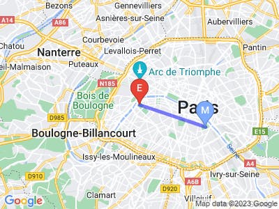
<img src=”https://maps.googleapis.com/maps/api/staticmap?center=Eiffel Tower,Paris&zoom=17&size=400x300&key=YOUR\_API\_KEY” />In the example above, we are generating a map image centered on the Eiffel Tower, Paris, with a zoom level of 17, width of 400 pixels, and height of 300 pixels. You can change these parameters to generate the desired map image according to your needs.
Specifying Location(s)
Specifying locations is crucial when working with the Google Static Maps API because it determines the map area you want to display. You create customized maps tailored to your application’s needs by specifying locations. We need to specify locations in the URL to center the map at the desired location and to add markers. By default, the center is a required parameter, but if you specify markers, paths, or visible parameters, the center becomes optional.
Location
The Static Map API makes it very easy to specify a location. You can provide a latitude/longitude pair for a place or a physical address. For physical addresses, the API will perform the Geocoding for you.
Please note that at the time of publishing of this video, the Static Map API limits the number of physical addresses to 15. This limit does not apply to latitude/longitude values. Check the Google Static Map API documentation for updates.
If you want to use more than 15 locations on the map image, use latitude/longitude values or a combination of physical addresses and latitude/longitude values.
Zoom
Zoom is a term you’ve likely heard before, especially if you’ve ever used online maps or navigation apps. In the Google Static Maps API context, zoom refers to the level of magnification or scale at which the map is displayed. It determines how much of the map’s details are visible and how far in or out you are viewing. Think of it as a way to control how close or far away you want to see a specific location on the map.
Now, let’s talk about Zoom levels. Google’s API represents Zoom levels as whole numbers, typically from 0 to 21. The higher the zoom level, the closer you are to the map’s surface, showing more intricate details. Conversely, lower zoom levels zoom out, giving you a broader map view.
The world fits into a single map image at the lowest zoom level (0). As you increase the zoom level, you’ll notice that the map becomes more detailed and specific. For example, at Zoom level 10, you might see the whole city; at Zoom level 15, you might see streets, individual buildings, and landmarks. If you zoom in to level 21, you can expect to see incredibly fine-grained details like specific addresses or even the layout of rooms inside buildings.
It’s important to note that only some zoom levels are available for some locations. Google’s API divides the world into a grid of tiles, and different zoom levels correspond to different levels of detail in these tiles. Some areas may have high-resolution tiles available at higher zoom levels, while others offer only basic information at lower zoom levels.
When using the Google Static Maps API, you can specify the desired zoom level by including it as a parameter in your API request. This allows you to customize the map’s level of detail to suit your application’s needs. For example, if you’re creating a map for a city guide app, you might want to use a higher zoom level to show streets and landmarks clearly. On the other hand, if you’re creating a map for a weather app that shows regional weather patterns, you might use a lower zoom level to display a wider area.
By controlling how much detail is displayed on your maps, you can provide a tailored experience for your users. Experiment with different zoom levels in the playground to see how the map changes at various zoom levels.
Size
The size parameter in the Google Static Maps API allows you to specify the dimensions (width and height) of the map image you want to generate. This parameter is crucial because it determines how big or small your map will be when displayed in your application.
You specify the size parameter by using the format ‘width x height,’ where ‘width’ and ‘height’ are the dimensions of your map in pixels. For example, if you want your map to be 400 pixels wide and 300 pixels tall, you would set the ‘size’ parameter to ‘400x300’ in your API request.
Note that the scale value of 2 will double the number of pixels in the map image.
When publishing this video, the Static Map API restricts the maximum size for images to 640x640 pixels. Check the API documentation for updates.
Choosing an appropriate size for your map is essential based on your application’s needs. Larger dimensions provide more detail and allow for a more extensive view of the map area, but they also result in larger image files and potentially longer load times. Smaller dimensions are more compact and load faster but may sacrifice detail. Keep in mind that the ‘size’ parameter doesn’t just affect the map’s dimensions but also its level of detail.
Additionally, consider the screen size and resolution of the devices your users will use when designing your application. Creating responsive designs that adapt to different screen sizes and orientations is a good practice. I encourage you to experiment with different sizes in the playground.
Map Type
The maptype parameter in the Google Static Maps API allows you to choose the type or style of map you want to display in your application. Google provides several built-in map types, each designed to serve different purposes and cater to various preferences.
The most commonly used map types are roadmap, satellite, terrain, and hybrid.
-
Roadmap: This is the default map type, and it displays a typical road map with streets, road labels, and essential features. The ‘roadmap’ type is excellent for general-purpose maps and navigation applications.
-
Satellite: The ‘satellite’ map type displays satellite imagery of the Earth’s surface. It provides a real-life, bird’s-eye view of locations. This type helps show the terrain, landscapes, or aerial views.
-
Terrain: The ‘terrain’ map type displays a physical map, emphasizing natural features like mountains, rivers, and vegetation. It’s handy for outdoor and topography-related applications.
-
Hybrid: The ‘hybrid’ map type combines satellite imagery with road labels and features. It provides the benefits of both satellite and road map views, making it useful for various applications.

To specify the map type you want, add the maptype parameter to your API request and provide the desired map type as its value.
The choice of map type depends on your application’s goals and the visual style you want to convey. For navigation and directions, ‘roadmap’ or ‘hybrid’ is often a good choice. For showcasing natural beauty or outdoor activities, ‘satellite’ or ‘terrain’ might be more suitable.
In summary, the maptype parameter in the Google Static Maps API gives you the power to customize the visual style of your maps. Whether you want a traditional road map or a satellite view, you can tailor your map to match your application’s needs and aesthetics.
Markers
Markers are essential components of any map and play a crucial role in highlighting specific points of interest or providing vital information to users. The markers parameter in the Google Static Maps API allows you to easily incorporate markers into your maps, enhancing their utility and aesthetics.
Markers can serve a wide range of use cases in your mapping applications:
-
Location Identification: You can use markers to pinpoint specific locations on the map, such as landmarks, businesses, or attractions. This is incredibly useful for providing directions or helping users identify critical points of interest.
-
Custom Icons: Markers don’t have to be generic pins. You can use custom icons as markers, especially for branding. For instance, if you’re building a store locator app, you can use your store’s logo as a marker.
-
Multiple Markers: You can add multiple markers to a single map to simultaneously showcase several points of interest. This is often used in applications like travel guides, where users need to see multiple attractions within a city.
Styling Markers
You can style markers and customize their appearance to match the design and theme of your application. Here are some standard marker styling options:
-
Color: You can change the color of a marker using the ‘color’ parameter. Google Static Maps API offers a variety of predefined colors like ‘red,’ ‘blue,’ ‘green,’ and more. This is handy for differentiating markers on your map.
-
Label: The ‘label’ parameter lets you add a single uppercase letter or number inside the marker. This is perfect for annotating map points, especially if multiple markers are on the same map.
-
Icon: If you want to use a custom image as a marker, use the ‘icon’ parameter. This opens up endless possibilities for customization. For example, you can use unique icons for restaurants, hotels, and other types of businesses on your map.
The markers parameter is valuable in your mapping toolkit, whether you need to mark specific locations, provide directions, or add visual interest to your maps.
Paths
The path parameter in the Google Static Maps API enables you to create custom routes, lines, and shapes on your maps. Whether you want to show a hiking trail, outline a geographical boundary, or display a driving route, the path parameter covers you.
Key Features and Use Cases
The path parameter is incredibly versatile, and it can be used in various ways:
- Drawing Routes: You can use it to draw routes between multiple points on your map. This is perfect for applications that require showing directions or travel routes.
- Geographical Boundaries: The ‘Paths’ parameter allows you to outline geographical boundaries such as city limits, national parks, or even custom regions of interest.
To use the path parameter, you must define the coordinates that make up the path. You do this by providing a set of latitude and longitude pairs or physical addresses representing the points along the path. These coordinates are then connected to form the way.
Styling the Path
The path parameter also offers styling options to customize the appearance of the path on your map:
- Color: You can specify the path’s color using the ‘color’ parameter. Google Static Maps API supports a variety of predefined colors, such as ‘red,’ ‘blue,’ ‘green,’ and more. You can also use hex values for colors.
- Weight: The ‘weight’ parameter allows you to control the thickness of the path. You can adjust this value to make the path stand out or blend in with the rest of the map.
Viewport
The Google Maps Static API viewport is the map area visible in the static map image. The viewport is determined by the center and zoom parameters, which specify the map’s center point and the zoom level, respectively.
The Static Map API provides the visible parameter to further customize the viewport by specifying one or more locations or areas that should be visible on the map. To use the visible parameter, you can specify a list of locations, which can be specified using latitude and longitude coordinates or physical addresses. The pipe character must separate the locations.
The visible parameter allows you to customize the viewport to show the map areas relevant to your application without highlighting them with a marker or path.
You can automatically instruct the Google Static Map API to calculate the appropriate zoom level by combining the visible parameter with markers or path.
Limitations
While the Google Maps Static Map API is a powerful tool for displaying static map images in web applications, it does have some limitations.
- One major limitation is that the static map images are not interactive, meaning that users cannot pan or zoom the map or interact with markers or other elements.
- Additionally, the resolution of static map images is limited, making it challenging to display detailed information or show a large map area in a single image.
- Another limitation is that the static map images are not updated in real-time, meaning that changes to the map data, such as new roads or buildings, may not be reflected in the static map images.
- Finally, the Google Maps Static Map API is subject to usage limits and pricing, which can make it expensive for high-traffic applications or applications requiring many map requests.
Despite these limitations, the Google Maps Static Map API remains a popular choice for displaying static map images in web applications, particularly for applications that do not require interactive maps or real-time updates.
I highly recommend visiting the Google Static Maps API documentation to dive deeper into this powerful tool. It’s a valuable resource for understanding the capabilities, features, and best practices associated with using static maps.