This article teaches the terminology and core concepts used in Google Maps Static Map API. Understanding these terms and concepts will help you better navigate and work with maps and location-based data in your applications.
Map
A map is a visual representation of an area, typically showing geographic features such as roads, buildings, and bodies of water. In the picture, you can see a map showing Effile Tower in Paris. You can enhance the map to show objects relevant to your website. The Google Maps API is a set of tools and services that allows developers to embed Google Maps in their websites or applications.

Position
To indicate a point of interest on a map, we need its geographic coordinates to specify its location on the surface of Earth. A position consists of two values: latitude and longitude.
Latitude
There are four directions: North, South, East, and West. Latitude specifies a location’s position in the north-south direction. The equator is an imaginary line that goes through the middle of the Earth and has 0 degrees latitude. Latitude is negative south of the equator and positive north of the equator. The latitude for Effile Tower is 48.8584.
Longitude
Longitude is used to specify a location’s position in the east-west direction. The Prime Meridian is an imaginary line from the North to the South Pole and passes through the Royal Observatory in Greenwich, England. The Prime Meridian longitude is 0. Longitude is negative west of the Prime Meridian and positive east of the Prime Meridian. The longitude of Effile Tower is 2.2945.

Zoom
Zoom is a positive number that defines the resolution or details shown on the map. The range of Zoom can be between Zero to 21. At 0 zoom level, the entire world is shown, and at 21 zoom level, streets and individual buildings are visible. Here are some examples of commonly used zoom levels.
- At Zoom 1, the World is shown
- At Zoom 5, the continent is visible
- At Zoom 10, City is shown
- At Zoom 15, Streets are visible
- At Zoom 20, Individual buildings can be seen
The pictures below show the Eiffel Tower in Paris at various zoom levels.

Marker
A marker is a visual indicator on a map representing a specific location or point of interest. You can change marker colors and use images as custom markers on a Google Map.
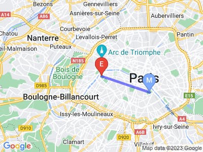
Path
A path is a set of one or more locations connected by a line. You can use a path to show routes or connections between locations on a map. In the picture below, the blue line is a path between two locations.
Geocoding
In day-to-day life, we don’t use geographical coordinates to describe locations but instead use physical addresses like Effile Tower Paris. Converting a physical address into geographic coordinates is known as Geocoding. The Google Maps Geocoding Service allows you to convert physical addresses into geographical coordinates that can be used on a Google Map.